Language:
|
Language:
|
|
Keywords: forecasting gold deposits, gold-bearing regions, global goldfield grid, nodal auriferous zones, gold-ore nodes. |
This work relates to global zoning and forecasting of mineral deposits, particularly gold. It shows the correspondences of the longitudes and latitudes of some largest gold mines with approximately equal intervals between them. Extrapolating found regularity to the entire surface of the Globe, the grid of 4 latitudinal and 9 meridional lines was obtained. Many of the 36 nodes in this global grid are close to other large gold deposits.
Discovered gold grid confirms and supplements the concept of the pulsation nature of geodynamic cycles Willis. Suggested areas for further research will help clarify the coordinates of the gold-bearing nodes of the network and to reveal its nature.
It proposed the directions of exploration the reason for the discovered regularity. Also it supposed the new auriferous regions in Africa, Antarctica, Canada, Caribean sea, Great Britain, Greenland and Russia. In addition, studies of the nature of this phenomenon will expand our knowledge about the terrestrial planets and enable a targeted exploring for mineral deposits there.
While studing a map of the minerals on a general World Atlas (where the biggest and the most famous minerals are indicated), I noticed:
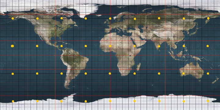
I assumed that on the Globe there is a "net" with "cells" with dimensions of 45° latitude and 40° longitude, the nodes of which can contain similar big gold-bearing regions as ones in SAR, India, Australia and Philippines. So, this "Global Gold Grid" (GGG) has 4 belts upon latitudes (60°N, 15°N, 30°S and 75°S) and 9 "lobules of orange" upon longitudes (0°, 4°E, 80°E, 120°E, 160°E, 160°W, 120°W, 80°W and 40°W). At the same time, from 36 of one's hypothetic nodes 13 are located in oceans and seas (## 14, 15, 16, 18, 19, 21, 24, 25, 27), 14 are available on land (although 4 from them are located in the sea: ## 1, 17, 20, 26) and 9 are located under the ice shield of Antarctica (2 from them - in the area of seas under the ice: ## 33, 36).
It can be expressed in a mathematical formula: longitude X = ( 60 - 45 ? Nx )°, latitude Y = ( 0 + 40 ? Ny )°, where Nx = 0 .. 3, Ny = -4 .. +4 (pic. 1).
|
-180° -170° -160° -150° -140° -130° -120° -110° -100°
-90° -80° -70° -60° -50° -40° -30°
-20° -10° +0° +10° +20°
+30° +40° +50° +60° +70° +80° +90° +100°+110°+120°+130°
+140° +150° +160° +170° +180°
|
||||||||||||||||||||
|
|
|||||||||||||||||||
And in fact 16 from 17 land nodes of GGG (except the Antarctic ones) have near gold deposits [3, 7] and they are being developed. Some of them are very big. The deviations are small - from 0 to a few degrees. Below you can find the table with data on these gold mines. The numbering of the GGG-nodes in the table goes from north to south and from east to west, first to embrace Eurasia. The closest towns [2] are shown for clarity. Deviation of less than 5 degrees are marked in red. This table shows also the Antarctic operating station of the world (permanent and seasonal). The temporary closed-down stations have the abbreviation "cons." Collapsed stations are not shown, but they also collected interesting information.
| No | Condit. latit. |
Condit. longit. |
Real latitude/ longitude |
Deviation | Country, region | Nearest objects | Goldfields | Notes |
| #1* | 60°N | 0°E | 56N 5W | 4S / 5W | N.-S. Europe: Scotland | Glasgow {56N 4W}, Tyndrum {56N 5W}, Wick {5845'N 309'W}. |
Cononish {5627'N 444'E}. | The node is in a sea nearby Shetlands. |
| #2 | 60°N | 40°E | 58N 41E ? | 2S / 1E | N.-S. Russia | Vologda {59N 40E}; Lubim {58N 41E}. |
They are surmised to be located in Lubim district of Yaroslavl region. | It is not found yet. |
| #3 | 60°N | 80°E | 54N 89E | 6S / 9E | S. Siberia, river Ob | Nizhnevartovsk {6057'S 7833'E}, Tymsk {5923'N 8016'E}. | Kommunarovskoe {5420'N 8915'E}, Saralinskoe {5414'N 8915'E}. | Find on N.-S. |
| #4 | 60°N | 120°E | 59N 117E | 1S / 3W | E. Siberia (Yakutia, river Lena) | Yakutsk {6202'N 12944'E}, Olekminsk {6023'N 12026'E}. |
Chertovo Koryto {5928'N 11649'E} and others. | |
| #5 | 60°N | 160°E | 58-64N 160-161E | 1N / 0,5E | E. Siberia (Pen. Kamchatka, river Kolyma) |
Magadan {5934'N 15048'E}, Evensk {6155'N 15914'E}, Л®rf {6022'N 16601'E}, Palana {5905'N 15957'E}. |
Ametistovoye {6030'N 16000'E}, Kubaka {6344'N 16001'E}, Ozernovskoe {5735'N 16047'E}. |
|
| #6 | 60°N | 160°W | 62-64N 158W | 3N / 2E | USA: Alaska | Anchorage {6113'N 14954'W}, Bethel {6048'N 16145'W}. |
Donlin Creek {6206'N 15811'W}, Illinois Creek {6425'N 15738'W}, Chicken Mountain {6220'N 15805'W}. |
|
| #7 | 60°N | 120°W | 57N 127W | 3S / 7W | Canada | Fort Nelson {5848'N 12142'W}, Fort Simpson {6152'N 12121'W}. |
Kemess {5704'N 12644'W}, Lawyers {5720'N 12710'W}. |
Find on N.-E. |
| #8 | 60°N | 80°W | 51-52N 72-74W | 8,5S / 7E | Canada: Hudson Bay, Pen. Ungava | Inukjuak {5827'N 7806'W}, Ivujivik {6225'N 7755'W}. |
Eastmain {5218'N 7205'W}, Troilus {5101'N 7428'W}. |
In Hudson Bay. Find on N.-S. |
| #9 | 60°N | 40°W | 60N 45E | 0 / 5E | S. Greenland (Den.): Cape Farvel (Uummannarsuaq) | Julianehab (Qaqortoq) {+6043'/+4602'}. | Nalunaq {6021'N 4450'W}. | Sea area close by c. Farvel. |
| #10 | 15°N | 0°E | 13-14'N 1E | 1,5'S / 1E | W. Africa: Niger | Niamey {1331'N 207'E}; Gao {1616'N 003'W}. |
Koma Bangou {1405'N 102'E}, Samira {1341'N 112'E}, Sefa Nangue {1314'N 100'E}. |
|
| #11 | 15°N | 40°E | 18-19'N 35E | 3,5'N / 5W | E. Africa: Sudan, Ethiopia | Asmera {1520'N 3855'E}; Kassala {1527'N 3624'E}. |
Kamoeb {1818'N 3522'E}, Hassai {1842'N 3523'E}. |
Find on S.-E. |
| #12 | 15°N | 80°E | 14-16°N 77°E | 0° / 3°W | S. India | Madras (Chennai) {1305'N 8016'E}, Nellore {1426'N 7958'E}. |
Ramagiri {1430'N 7640'E}, Hutti {1612'N 7643'E}. |
|
| #13 | 15°N | 120°E | 16-17°N 121°E | 1,5°N / 1°E | N.Philippines (is. Luzon) | Manila {1435'N 12100'E}, Baguio {1625'N 12036'E}. |
Baguio {1624'N 12039'E}, Dinkidi {1620'N 12126'E}, Lepanto {1651'N 12048'E}, Marian {1651'N 12048'E}. |
|
| #14 | 15°N | 160°E | (Pacific Ocean) | |||||
| #15 | 15°N | 160°W | (Pacific Ocean) | |||||
| #16 | 15°N | 120°W | (Pacific Ocean) | |||||
| #17* | 15°N | 80°W | 12°N 85°W | 3°S / 5°W | C. America: Cuba, Nicaragua, Panama |
Puerto Cabezas {1401'N 8322'W}; Kingston {1759'N 7648'W}; Holguin {2053'N 7615'W}. Bartlett Deep (Cayman Trough) {1834'N/8307'W} - hydrothermal zone. |
Bonanza {1407'N/8431' W}, La Luz {1347'N/8448' W} and others. |
Node on the sea between Jamaica and Nicaragua. |
| #18 | 15°N | 40°W | (Atlantic Ocean) | |||||
| #19 | 30°S | 0°E | (Atlantic Ocean) | |||||
| #20* | 30°S | 40°E | 25°S 31°E | 4°S / 9°W | S. Africa: SAR | Pretoria {2544'S 2815'E}, Durban {2951'S 3101'E}; Maputu {2555'S 3235'E}. |
Agnes {2550'S 3104'E}, Barberton {2543'S 3107'E}, East Rand {2543'S 3107'E}, New Consort {2539'S 3105'E}, Pioneer {2550'S 3058'E}, Fortuna {2548'S 3103'E}, Fairview {2543'S 3107'E}, Sheba {2543'S 3108'E} (SAR); РЁдЈ‘нќ…н°Ёиџ»2600'S/3113'E} (Swaz.). |
The node is in an ocean. Find on N.-E. from the gold-mines. |
| #21 | 30°S | 80°E | (Indian Ocean) | |||||
| #22 | 30°S | 120°E | 28-30S 117-119E | 1N / 2W | S.-W. Australia | Perth {3157'S 11552'E}, Kalgoorlie {3045'S 12128'E}. |
Gibson {2945'S 11710'E}, Star Mining {2805'S 11750'E}, Youanmi{2836'S 11849'E}, Saint George {2804'S 11750'E}, Hill 50 {2802'S 11747'E}. | |
| #23 | 30°S | 160°E | (Pacific Ocean) | is. Lord Howe (Austral.) {3145'S 15815'E}. | ||||
| #24 | 30°S | 160°W | (Pacific Ocean) | |||||
| #25 | 30°S | 120°W | (Pacific Ocean) | |||||
| #26* | 30°S | 80°W | 30-31S 71W | 0,5S / 9E | S. America: Chile | Antofagasta {2338'S 7024'W}. |
Andacollo {3014'S 7106'W}, Punitaqui {3047'S 7129'W}. |
It is in an ocean. |
| #27 | 30°S | 40°W | (Atlantic Ocean) | |||||
| #28 | 75°S | 0°E | Antarctica | Novolazarevskaya (RF) {70S 11E}; Kohnen (Germ.) {75S 00}; НЅкі°жћЁInd.) {71S 12E}; SANAE IV (SAR) {72S 03W}; Tor, Troll (Norw.) {72S 5E}. | ||||
| #29 | 75°S | 40°E | Antarctica | Molodezhnaya (RF, cons.) {67S 45E}; Dome Fuji {77S 40E}, Mizuho {71S 44E}, Showa {69S 40E} (Jap.). | ||||
| #30 | 75°S | 80°E | Antarctica |
Mirny (RF) {66S 93E}, Progress (RF) {69S 76E}, Soyuz (RF, cons.) {70S 68E}; Davis (Australia) {68S 77E}, Law-Racovita (Rom.) {69S 76E}. |
||||
| #31 | 75°S | 120°E | Antarctica | Concordia (It., Fr.) {75S 123E}, Vostok (RF) {78S 106W}. |
||||
| #32 | 75°S | 160°E | Antarctica | Leningradskaya (RF, cons.) {69S 159E}; McMurdo (USA) {78S 167E}; Scott (N. Zel.) {78S 167E}. |
||||
| #33* | 75°S | 160°W | Antarctica | The Ross sea. | ||||
| #34 | 75°S | 120°W | Antarctica | Russkaya (RF, cons.) {74S 136W}. | ||||
| #35 | 75°S | 80°W | Antarctica | Parodi (Chile) {80S 81W}. | ||||
| #36* | 75°S | 40°W | Antarctica | Bellingshausen (RF) {62S 58W}; Belgrano II (Arg.) {78S 35W}; Frei (Chile) {62S 58W}. | A region of the Weddell Sea. |
I published these suppositions in 2001 on myself website [10]. In April 2012, I reported on this subject in the Saratov State Technical University on the All-Russian Conference "Co-evolution of geosphere, from the core to the Cosmos (Saratov).
Are these coincidences accidental or natural? If they are natural the following questions appear:
The author of this article already has some observations and assumptions as regards a number of these points. He found an additional number of patterns and features that allow to define a gold-bearing area more accurate. But as he is a professional analyst but not a geologist he would like to discuss these questions with a scientific community and develop a technology of finding goldfields together according to the described "net", if it is real of course.
But even now it is possible to show the following perspective places for exploration works. This is not only an exploration of gold deposits in the new zones, but also more accurate definition of the probable gold-bearing areas on the well-known auriferous zones.
In 2001 I wasn't aware of the goldfields in Scotland and Greenland - I had only a guess-work.
Besides, I presumed the existing of a gold-field region in Northern-Western Russia (nearby Vologda-city approximately). The interesting point is that on April 1, 2004 website Bullion.ru (dedicated to prices for noble metals) published an article that fields of gold and diamonds are assumed to be spaced in Lubim district of Yaroslavl region [8]. Lubim-town {58°21' нћѕнїЁ. 40°42' ..} is located near the Vologda-city {59°13' нћѕнїЁ. 39°54' ..}. It could be the "1st-of-April joke" but this conjunction is amusing. Then I found the confirmation. The presence of alluvial gold in the Vologda region and surrounding areas (Kostroma, Kirov) is corroborated by other information from the Internet [9]. By the way, not far from these places within Buy-town area of the Kostroma region there is the Uglich Break (58°29' North and 41°31' East). And at a small distance to the west but in any case geographically close to this place there is the source of the Great Russian river Volga (57°15' North and 32°28' East).
As regards the Antarctic "gold nodes" I would like to say that their exploration is not hopeless too. First and foremost they are situated not far from the sea side that is melting. At least it would be better to place scientific exploration stations within these nodes regions (or to move the nearest stations there). Some stations are very close to the nodes (deviation less than 5): German "Kohnen" (node 28), Japanese "Dome Fuji" (node 29) and Italian-French "Concordia" (node 31). These gold provinces in Antarctica could be carried out an international project for the extraction of gold. Overview of the Antarctic nodes, taking into account climate, thickness of ice, location of research stations of the world is the special article.
According to a preliminary hypothesis, which is verified by the author of this work, closer to the nodes goldfields are ore deposits and more distant goldfields are placer. Is not excluded that gold placers formed not only in underwater and terrestrial conditions, but also underground. So, to 3 factors of placer formation (wind, rain, rivers) can be added and others, yet unknown to us. Perhaps this is the fourth factor was decisive in forming the South African gold, far from the ocean gold-bearing node.
We hope that this article be interested in geological exploration institutes and mining companies.
In conclusion I would like to add that this study began in the early 80s. Then, as a student, I became interested in an article in the magazine "Technique for Youth" about a possible crystalline form of the Earth core and phenomena on its vertices. Then I noticed gold deposits on some nodes of the dodecahedral network. My observation was a note in the article in the "TM" for January 1982 ( 1). Subsequently I was revealed auriferous network of 36 nodes as described in this article.
|
Keywords for seeking about Global Goldfield Grid:
geographic goldfield regularity, global goldfield grid, auriferous region,
Earth nuclear nanotetrahedron, geologic gold-points, World goldnet, GGG.
|
|
|
|
|
|